Lessons in resilience.
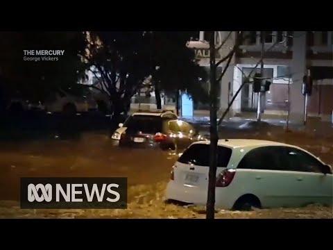
Hobart is a city known for its risk of catastrophic fire, such as the devastating wildfires of 1897-98 and 1967. As the second-driest city in Australia, until last week it was easy to forget that Hobart is also vulnerable to serious flooding. Like many cities, Hobart’s closeness to nature can be a double-edged sword – the hilly terrain affords spectacular views of the mountain and the river, but makes the city especially prone to wildfire and flash-flooding.
Hobart’s lack of preparedness for the scale and intensity of the May 2018 flood is also partly attributable to the city’s postwar planning. So how can Hobart and cities like it become more resilient to increasingly frequent natural disasters?
Read more: Higher density in a flood zone? Here's a way to do it and reduce the risks
A history of vulnerability and risk
Like it or not, disasters are part of the urban landscape. So too is social inequality. And the two can be mutually reinforcing – socially isolated and disadvantaged residents are often less able to cope when disaster strikes. They may, for example, lack insurance or be less mobile.
Social cohesion is a key element in community disaster recovery, helping cities “bounce back” after an event. But good land use planning is also important to avoid creating future problems.
Read more: A healthy environment shouldn't just be for the rich
Planning (non)-responses
Like the rest of Australia, historically city planning in Hobart was characterised by disconnection from nature. Creeks and streams were filled in, built over or walled off (taming nature), creating risks of catastrophic failure in unexpected conditions. This approach also overlooked the important